Drones have changed many industries by making work faster, more accurate, and safer. In agriculture, drones help farmers monitor crops, manage irrigation, and apply pesticides, covering large areas quickly and precisely. This not only increases productivity but also saves on labor costs and reduces risks for workers.
Drones are also used in urban planning, mining, and environmental conservation. They create detailed maps, track farm animals and wildlife, and check environmental impacts with high accuracy. Because they can take clear, real-time pictures from the air, drones have become essential tools for many modern jobs.
Both small businesses and large companies are using drones. Small businesses use them for local projects, while big companies use advanced drones for larger tasks. The global market for commercial drones is expected to grow by 57.5% each year from 2022 to 2030, showing how quickly this technology is being adopted.
The Use of Drones in Cartography
What is Cartography?
Cartography is the science and art of making maps that show different areas. Traditionally, mapmakers used ground surveys, satellite images, and manual drawing to create these maps. This involved measuring distances and angles on the ground, interpreting aerial photos, and drawing maps by hand. While these methods worked, they were often slow, required a lot of effort, and sometimes weren’t very accurate due to environmental challenges.
Drones in Cartography
Drones have changed how we make maps by making the process faster and more accurate. With high-resolution cameras and advanced sensors, drones can take detailed aerial pictures and gather topographical data. This method, called drone surveying, has many benefits over traditional methods:
- Faster Surveys: Drones can quickly cover large and hard-to-reach areas, saving time.
- High Accuracy: Advanced sensors and GPS ensure precise measurements, often better than traditional methods.
- Up-to-Date Data: Drones capture real-time data, providing current information.
- Safety: Drones remove the need for surveyors to go into dangerous or difficult terrain.
People now use drones for various mapping tasks, like land surveying, city planning, disaster response, and environmental monitoring. For example, drones can create 3D models of construction sites, track changes in land use, and assess damage after natural disasters. The ability to quickly and accurately make high-quality maps makes drones essential tools in modern cartography.
How Accurate is Drone Cartography?
Drone cartography is highly accurate due to advanced technology. High-end drones with precision sensors and GPS can achieve accuracy down to a few centimeters. For example, some professional-grade drones can be accurate to about 1 cm under ideal conditions. This level of precision often exceeds traditional surveying methods, making drones a reliable tool for creating detailed and accurate maps.
How Does Drone Surveying Work?
Surveying with a drone involves several key steps to collect accurate data and create maps:
- Planning the Mission: Before flying, plan the survey by defining the area to be mapped and setting flight parameters like altitude, overlap, and flight paths. Software tools help automate this process.
- Setting Up Ground Control Points (GCPs): To improve accuracy, place ground control points throughout the survey area. These marked points will be used later to align and scale the drone’s data accurately.
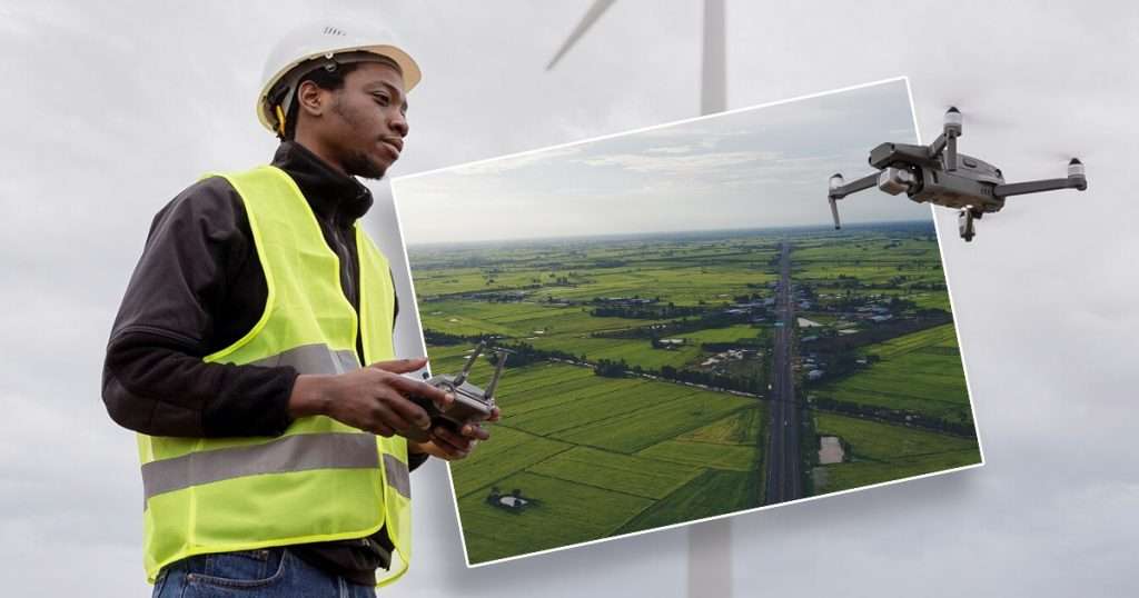
- Flying the Drone: Launch the drone and follow the pre-planned flight path. The drone will capture a series of overlapping aerial images as it flies. Many drones have automated flight systems to ensure consistent data collection.
- Data Processing: Once the flight is complete, upload the images to specialized software, where they are processed into a cohesive map. This software uses techniques like photogrammetry to stitch the images together, creating high-resolution maps and 3D models.
- Analyzing the Data: With the map or model created, analyze the data for your specific needs. This could involve measuring distances, assessing terrain, or monitoring changes over time.
Drone: Biggest Factor for Success in Drone Surveying
Success in drone surveying depends on both the type and features of the drone used, as well as the skills of the pilot. Both elements are crucial for achieving accurate and efficient results.
Types of Drones for Surveying
Different types of drones are suitable for various surveying needs, each with specific features that enhance their capabilities:
1. Multi-Rotor Drones
Multi-rotor drones have multiple rotors (usually four or more) and are highly maneuverable. They are best for short-range surveys, detailed inspections, and areas requiring precise control. These drones are easy to fly, can hover in place, and are ideal for capturing high-resolution images of small areas.
2. Fixed-Wing Drones
Fixed-wing drones look like small airplanes with fixed wings. They are best for large-area surveys, agricultural mapping, and long-distance flights. These drones have longer flight times, can cover greater distances, and are more efficient for large-scale mapping projects.
3. Hybrid Drones
Hybrid drones combine elements of both multi-rotor and fixed-wing drones. They are best for versatile applications that require both long flight times and precise maneuverability. These drones can take off and land vertically like multi-rotor drones but have longer flight durations like fixed-wing drones.
4. LiDAR Drones
LiDAR drones are equipped with LiDAR sensors that emit laser pulses to measure distance. They are best for creating highly accurate 3D models and topographical maps, especially in dense vegetation or challenging terrains. These drones provide detailed elevation data and can penetrate through foliage, making them suitable for forestry and environmental surveys.
Essential Drone Pilot Skills
A skilled pilot is key to successful drone surveying. Here are some essential skills a pilot should possess:
- Technical Proficiency: Pilots need to know how to operate different types of drones and their equipment. They should be familiar with flight planning software and data processing tools.
- Navigation Skills: Pilots must be able to navigate drones accurately over the survey area, ensuring complete coverage. They need knowledge of GPS and other navigation systems to maintain precise flight paths.
- Safety Awareness: Pilots should understand and follow safety regulations and guidelines. They must be able to identify and mitigate potential risks during flight operations.
- Problem-Solving Abilities: Pilots need to think quickly to handle unexpected situations, such as changing weather conditions or technical malfunctions. They should be adaptable to adjust flight plans and strategies as needed.
- Attention to Detail: Pilots must ensure all data is accurately captured and properly aligned with ground control points. They should meticulously review collected data to identify and correct any errors.
- Communication Skills: Pilots need effective communication skills to work well with team members and clients. They should be able to explain technical information and survey results in an understandable manner.
The Future of Drones in Cartography and Beyond
Drone technology is improving every day, bringing new features and capabilities. These advancements are making drones even more useful for cartography and other industries. As drones get better, they will become more accurate, fly longer, process data faster, and be safer to use. This means that people in fields like mapping, surveying, agriculture, and construction will find drones even more valuable in the future. With continuous innovation, drones will open up new possibilities and applications, leading to exciting developments across many sectors.